Routes
![]()
![]()
![]()
![]()
![]()
![]()
![]()
![]()
![]()
![]()
Rochester Trolley is planning several routes, building a true system that will provide mobility and accessibility to the entire Greater Rochester Community and on to the Finger Lakes region. Click here for the draft of our system map, here for the Charlotte to Downtown route.
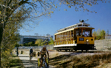
(photo courtesy of John Smatlak's Railway Preservation Resources)
Our Proposed Routes: (Click here for maps prepared by Otto Vondrak: map 1 / map 2 / map 3)
- 1. PaeTec Park to the U of R: PaeTec Park stadium,
through the historic Susan B. Anthony neighborhood, through Rochester's
historic subway tunnel, across the Genesee River, and along the East
side of the river, into the University of Rochester campus.
- 2. Downtown Circulator: This route would loop continuously
from State Street to Court Street to Chestnut to Andrews, crossing several
other lines for transfers.
- 3. RIT to UR to Downtown. This would likely use a
street-running streetcar on East River Road from RIT's campus, across
Jefferson, along the Genesee River, and finally turning onto former
Erie and Lehigh Valley right-of-way owned by the University of Rochester,
crossing route 390 and the canal using the Lehigh Valley RR bridge,
operating as a streetcar on UR's Park Lot access road, then using Intercampus
Drive, and crossing the Genesee River using the three existing Erie
RR low bridges. On the West side of the River, our route would continue
the Erie RR route, paralleling the existing pedestrian trail along the
River, and turning into a streetcar line on Exchange Boulevard, going
to Plymouth Ave., onto Morrie Silver, and then Brown Street, looping
to return.
- 4. Charlotte and the Port of Rochester to High Falls Downtown, crossing the Hojack Swing Bridge and using the Rochester Running Branch (BeeBee line), passing along the East side of the Genesee River, along Seneca Park Zoo, crossing St. Paul Street, entering the City, then crossing under St. Paul Street and crossing the Genesee River on the existing trestle bridge, and stopping in the High Falls area in front of the dormant BeeBee Station. A possible streetcar loop could be included in the High Falls area. Here we strive to achieve the shared use with the recreational trail efforts already underway.
- 5. Charlotte and the Port of Rochester to Seabreeze, crossing the Hojack Swing Bridge and using the Hojack right-of-way as much as possible, with a possible streetcar section on Lake Shore Boulevard and/or Culver Road to reach Seabreeze. Here again, we strive to achieve the shared use with the recreational trail efforts already underway.
- 6. SUNY Brockport to Downtown: This would use the former Falls Road line, which currently has tracks to just slightly East of Brockport. A trail exists on part of that right-of-way, and we would strive to achieve the shared-use trail approach. This line would likely terminate in the High Falls area, and might include a short stretch of streetcar line. Currently, the operating rail line is owned by Genesee Valley Transportation, and we believe that the County of Monroe owns the remainder of the Falls Road right-of-way.
- 7. Nazareth College to St. John Fisher College to Downtown: Beginning in the Village of Pittsford, this streetcar line would use East Ave.(Route 96) to go from the Village to Nazareth, to Fisher, and then along East Ave. through the museum and entertainment district into the City, and then turn onto Main Street to connect with other lines.
- 7.5 Village of Pittsford (Schoen Place) to Downtown: Beginning in the Village of Pittsford, this streetcar line would use Monroe Avenue (Route 31) to go from the Village along the entire length of Monroe Ave., supporting all of the retail establishments and destinations in the Monroe Ave. corridor.
- 8. Downtown to the Airport: As an extension of the East Ave. streetcar line, this would continue on Main St. out towards Chili Avenue, and would then turn towards the Airport using Brooks Avenue.
- 9. University Avenue Cultural district: This line would branch off of the East Ave. line at the Can of Worms, following University its entire length, turning onto Main Street and then reconnecting with the line from East Ave.
- 10. MCC to RIT: This streetcar line would take Brighton Henrietta Townline Road West to RIT, turn around on RIT's campus, take Jefferson Road East to Winton Road North, turning back onto Brighton Henrietta Townline Road. This touches the Henrietta shopping district.
- 11. MCC to U of R to Downtown: This streetcar line would take South Ave. South past Highland Park to East Henrietta Road to MCC, continuing to Jefferson Road West, to West Henrietta North to Mount Hope North to Clinton Ave.North to Pleasant St. West, back to South Ave. South.
- 12. Greece to Downtown: This streetcar line would run from roughly the Greece Ridge Center on West Ridge Road, through to Lake Ave. / State St., ending in the High Falls area.
- 13. Downtown to Irondequoit: This streetcar line would go from the High Falls area to St. Paul Blvd. to East Ridge Road to Irondequoit Mall, and turn to take Culver Road down to Seabreeze and return.
Later phase:
- Expand to provide "interurban" rail transport to serve the Finger Lakes Region from Rochester, including Victor to Canandaigua to Geneva to Ithaca, service from Henrietta to the Livonia / Avon / Lakeville area, etc.
Consider-- visitors from Toronto are already used to using streetcars:
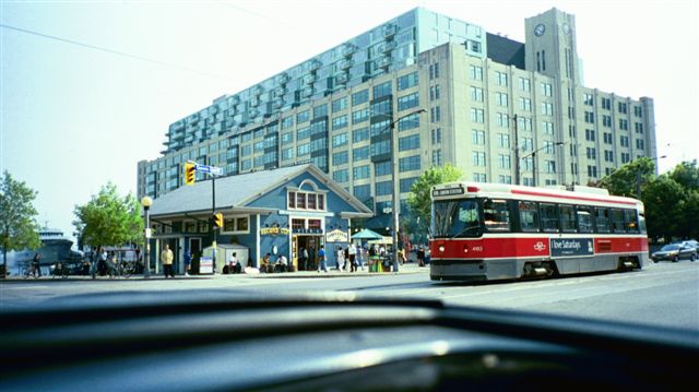
photo courtesy of Joseph Brzezowski, Transit Gallery
Copyright 2003-2008 -- Rochester Trolley & Rail Corporation
Logo Design by:
![]()